Firefighters successfully defended containment lines during Saturday's extreme Particularly Dangerous Situation Red Flag conditions, keeping the Rowe Creek Complex mostly within its footprint. The lightning-caused fire is now estimated at 313,439 acres and is 55% contained.
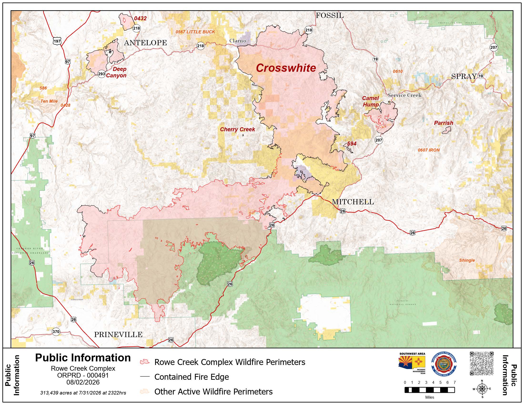 Public Information Map from August 2, 2026.
A new unified command led by Southwest Complex Incident Management Team 2 and the Oregon State Fire Marshal Blue Team took over management of the fire Sunday morning. They are overseeing 2,332 personnel dedicated to the incident.
While most fire lines on the west side held during Saturday's high winds, the fire did jump established lines near Tompkins Pass, where crews quickly responded to stop the spread. On the southwest side of the fire near Prineville, firefighters used helicopters to drop water on the fire's edge to keep lines secure.
West of the Mill Creek Wilderness, strong winds pushed the fire east toward the wilderness area. Firefighters responded by building new dozer lines to create a barrier. Overnight, cooler temperatures and higher humidity helped reduce the fire's intensity.
Sunday, crews are focusing on:
- Protecting Communities: The top priority is holding the fire on the south side near populated areas, including the Mill Creek Wilderness, Trout Creek, and Tompkins Pass.
- Defending Homes: Oregon State Fire Marshal task forces are moving into the Mill Creek and Johnson Creek areas to perform structural triage and identify defensible spaces.
- Quick Response: Initial attack teams are standing by to quickly respond to any new fires that might start in the bone-dry fuels.
Weather today is expected to be more moderate, with temperatures reaching the upper 70s and wind gusts up to 21 mph. Humidity may drop to 15%. On Monday, conditions will turn calmer and hotter, with temperatures reaching the 80s.
Air quality in the area has recently ranged from good to hazardous. For detailed local air quality information, visit fire.airnow.gov, and for information on mitigating the effects of wildfire smoke, visit epa.gov.
Level 1, 2, and 3 evacuation notices remain in effect. Residents can find the latest evacuation maps for their specific county at the following links:
- Crook County: https://protect.genasys.com/
- Jefferson County: https://tinyurl.com/bdz88ufn
- Wasco County: https://perimetermap.com/wascocounty-or
- Wheeler County: https://arg.is/1aDrHm4
A Red Cross shelter is open at the East Side Church (3174 NE Third Street) in Prineville.
Closures and Restrictions: Specific closure and restriction information can be found at these resources:
- Ochoco National Forest: fs.usda.gov/r06/ochoco/alerts
- Bureau of Land Management (BLM): blm.gov/programs/fire/regional-info/oregon-washington/fire-restrictions
- John Day Fossil Beds National Monument: nps.gov/joda/planyourvisit/conditions.htm
- Public/Private Land Fire Restrictions: https://centraloregonfire.org/fire-restrictions/
- Road Conditions: tripcheck.com
A Temporary Flight Restriction (TFR) is in place; visit tfr.faa.gov/tfr3 for more information. Unauthorized drone flights are illegal and will force the grounding of all firefighting aircraft.
Moving forward, all information on the Rowe Creek Complex will be consolidated through these official sources:
- Fire Information Line: 541-800-1280 (8 a.m. - 8 p.m.)
- Inciweb: inciweb.wildfire.gov/incident-information/orprd-rowe-creek-complex
- Facebook: facebook.com/rowecreekcomplex