
Firefighters and structural task forces are focusing on point protection and public safety Sunday as the Rowe Creek Complex continues to burn through grass, juniper, and timber in Wheeler, Wasco, and Crook counties. The lightning-caused complex has reached 126,978 acres with 0% containment.
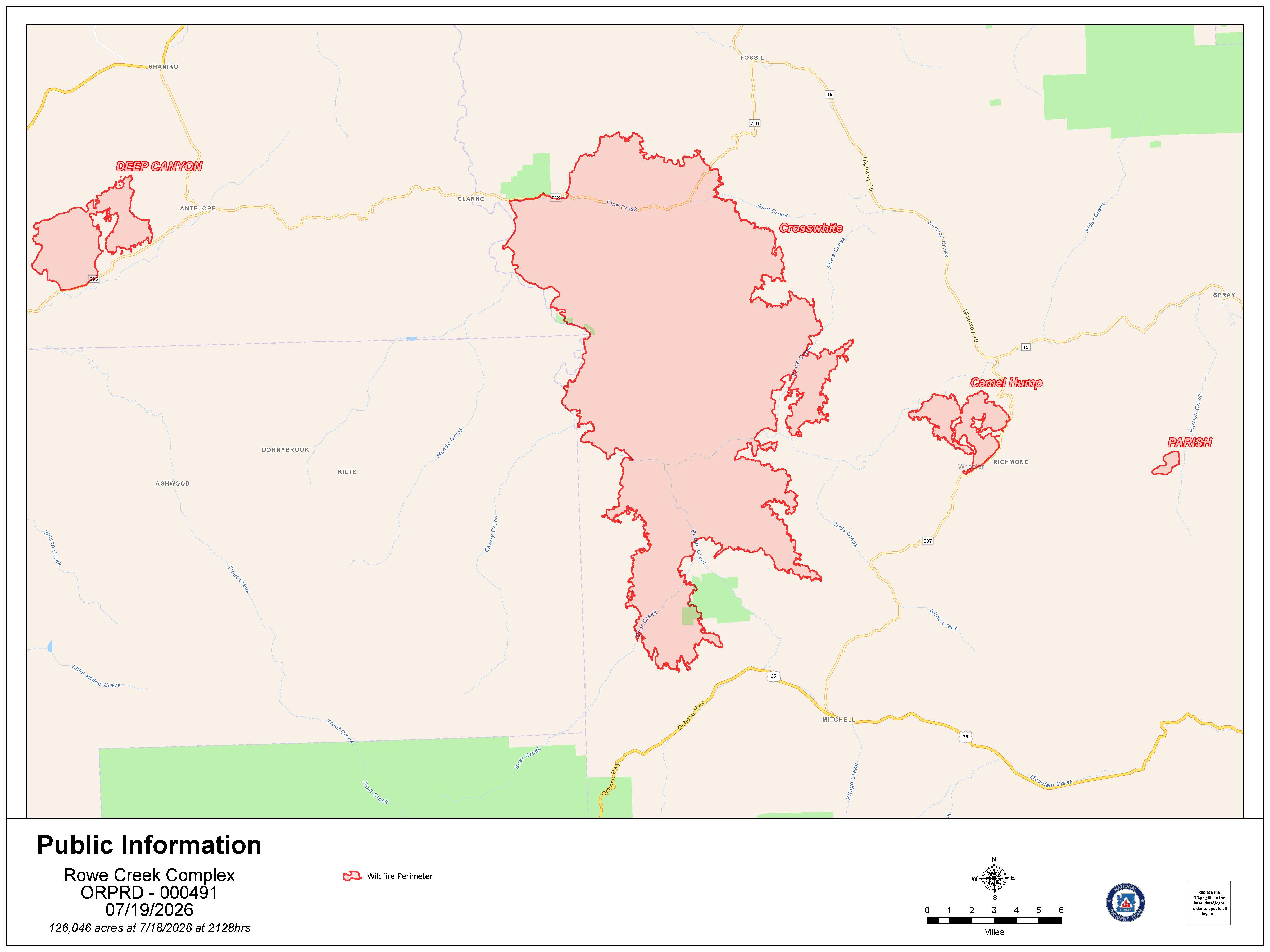 Rowe Creek Fire Map from July 19, 2026.
The complex was recently renamed to include several active fires in the region. Most of these have merged into the Crosswhite Fire, which now spans 113,046 acres. On Saturday, winds pushed the Crosswhite Fire southwest toward Mitchell, though northern lines held steady along Clarno and Rowe Creek roads.
With containment holding on the eastern portions of the Crosswhite Fire, the Oregon State Fire Marshal is reassigning structural task forces to the southern flank today. This move comes in response to forecasted weather expected to increase fire activity along the western ridge. These teams will remain available through the night to defend homes alongside local Rangeland Fire Protection Association members and wildland crews.
Other fires within the complex include:
- Deep Canyon Fire: At 8,062 acres, this fire saw minimal growth on Saturday, allowing crews to establish control lines.
- Camel Hump Fire: Now 4,480 acres, this fire experienced increased activity Saturday afternoon. Firefighters successfully established a dozer line along Highway 207, though steep terrain to the southeast continues to challenge suppression efforts.
- Parrish Fire: This 410-acre fire remains separate from the larger merged area. Moderated fire behavior has allowed crews to begin mop-up operations and establish a perimeter.
Weather conditions remain a significant concern, with temperatures expected to reach 95 degrees amid low humidity. While aircraft support is available, heavy smoke and regional fire activity have limited visibility for aerial operations. A Temporary Flight Restriction is in place, and officials remind the public that unauthorized drone flights will ground all firefighting aircraft.
The Wheeler County Sheriff’s Office has implemented Level 1, 2, and 3 evacuation notices for nearby communities. Public land closures are also in effect, including all Bureau of Land Management lands along the John Day River from Service Creek to the Columbia River. Additionally, the National Park Service has closed the Clarno and Painted Hills units of the John Day Fossil Beds National Monument.
.JPG)
.JPG)
.JPG)
.JPG)