Firefighters have increased containment to 20 percent on the 39,439-acre Grasshopper Fire as the blaze moves toward the Highway 35 corridor. More than 1,320 personnel are now assigned to the lightning-caused fire.
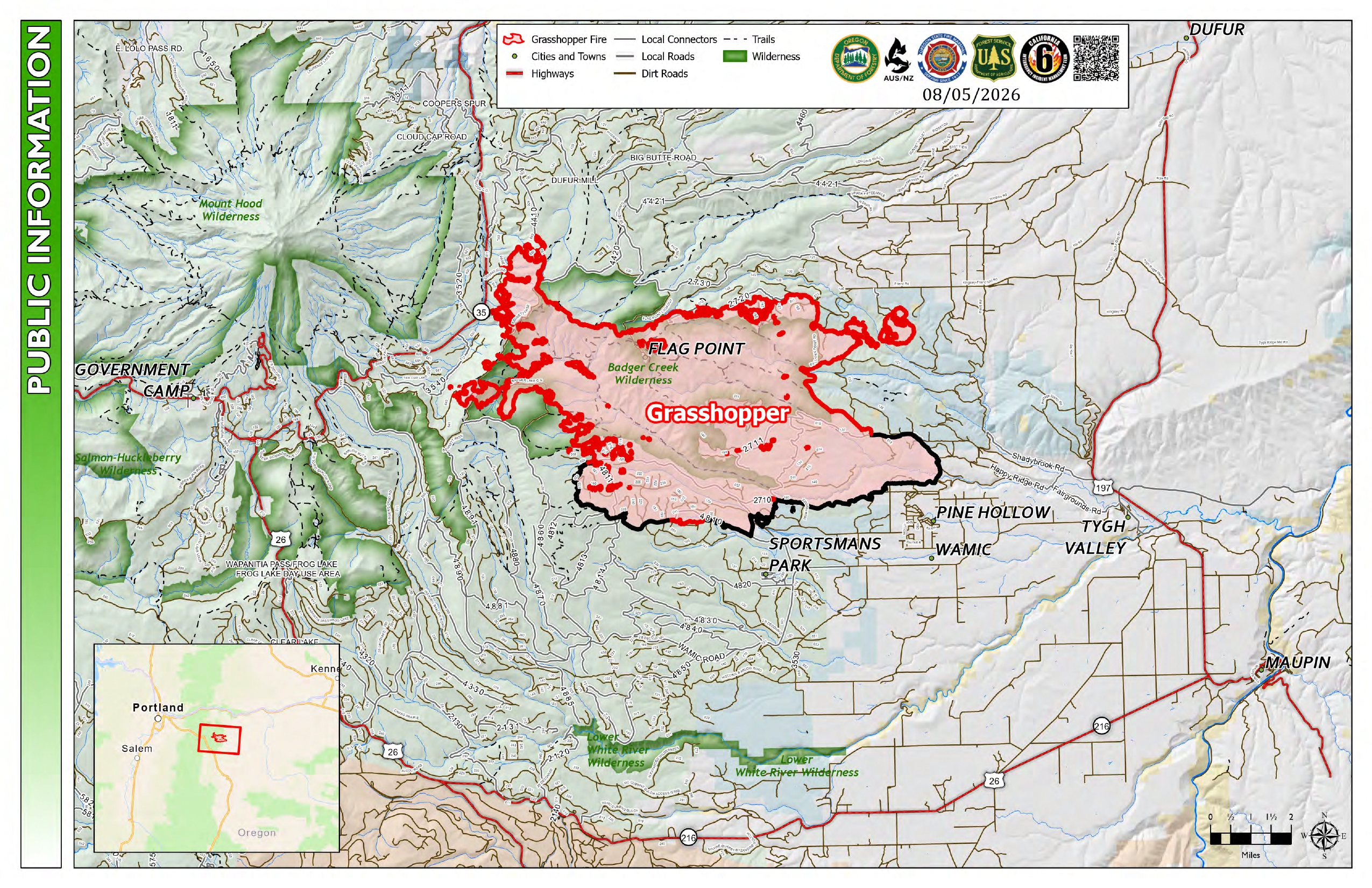 Grasshopper Fire Map from August 5, 2026.
On Tuesday, crews made significant gains in the northeast, successfully securing a slopover, an area where the fire had crossed a control line, and reinforcing new barriers. On the northwestern edge, the fire reached Bennett Pass and is continuing to move around Lookout Mountain.
Today, the fire is projected to move toward the Badger Bowl area. Fire managers expect the fire’s intensity to decrease as it approaches Highway 35, which remains open to traffic. Hand crews and bulldozers are currently working to build suppression lines along Forest Roads 45 and 50 just east of the highway.
The Oregon State Fire Marshal continues to support the incident. While the main fire remains several miles away, these teams have completed structural triage and preparation around the Mt. Hood Meadows Resort. Today, they will continue triage work on the western side of the fire and assist with burn operations, intentionally setting small fires to remove fuel, along the northern edge.
Weather and Smoke Impacts: A significant weather shift is expected today. While the morning began with hot, dry easterly winds, a shift to westerly winds is forecast for mid-afternoon. This change is expected to help slow the fire's spread toward Highway 35.
However, smoke will cause major air quality issues across the region today.
- Portland and Salem: Expect significant smoke impacts through tonight.
- Highways 26 and 35: Air quality between Rhododendron and Parkdale will remain Hazardous, potentially reducing visibility for drivers.
- Maupin and Tygh Valley: Conditions are expected to reach Hazardous levels this morning before slightly improving this afternoon.
Level 3 "Go Now" evacuation orders remain in effect for parts of Hood River and Wasco counties, while Clackamas County has issued Level 1 "Ready" notices.
- Evacuation Maps: perimetermap.com (Wasco/Hood River) and clackamas.us/clackcoalerts (Clackamas).
- Shelters: A human shelter is open at South Wasco County High School in Maupin; large animals can be taken to the Sherman County Fairgrounds in Moro.
- Forest Closures: A large area of the Mt. Hood National Forest is closed. Forest Road 44 is temporarily closed south of Forest Road 17, with a detour available via Brooks Meadow to Highway 35.
- Drones: A Temporary Flight Restriction (TFR) is in place. Unauthorized drone flights will immediately ground all firefighting aircraft.